The coastal section of Balbriggan sits on a complex mix of glacial till and shale bedrock, where the groundwater table fluctuates dramatically with the tide just a few hundred meters from the shoreline. Over the past decade, we have seen mild winters accelerate weathering in the steep cuttings behind Bremore, triggering shallow slips that catch landowners off guard. When a slope shows signs of distress—tension cracks at the crest, a slight bulge at the toe—analyzing the failure mechanism before it progresses is simply good practice. In Balbriggan projects, we routinely pair our slope stability analysis with a CPT test to profile the soft silty lenses that often sit between till layers, and a test pit investigation where access allows a direct look at the shear surface. Our approach follows Eurocode 7 (EN 1997-1:2004) Design Approach 1, combining partial factors with ground parameters measured in our INAB-accredited laboratory. The analysis quantifies the margin of safety for both short-term undrained conditions and long-term drained scenarios, because in this town the critical season shifts depending on whether you are 50 meters or 2 kilometers from the Irish Sea.
In Balbriggan, a slope that stands through the summer can fail in November—not because the geometry changed, but because the pore pressure regime flipped.
Methodology applied in Balbriggan
Risks and considerations in Balbriggan
The difference between a slope in the Balrothery area and one along the Barnageeragh Road comes down to drainage history. Balrothery sits on thicker, sandier till that drains reasonably well until the wet winter saturates it from below; failures there tend to be deep-seated rotational slides with a few days of warning—cracks opening, fences leaning. Barnageeragh, by contrast, has a thin veneer of topsoil over weathered shale, and we see translational slides that move fast after a single heavy downpour. The common thread is water. When the analysis ignores a broken field drain or a neighbor’s unplanned excavation at the toe, the factor of safety drops below 1.0 without anyone noticing. Another pattern we find in Balbriggan is slope creep caused by repeated loading from construction traffic on adjacent sites—small movements that accumulate over years and eventually trigger a larger failure. Our risk assessments classify slopes by consequence class (CC1 to CC3), matching the geotechnical category defined in Eurocode 7, and we recommend monitoring with inclinometers for any slope where the calculated factor of safety falls between 1.0 and 1.2 for the critical case. In coastal Balbriggan, we also model toe erosion from wave action using a 50-year shoreline retreat projection, because a stable slope today can become an unstable one simply because the sea takes away its support.
Our services
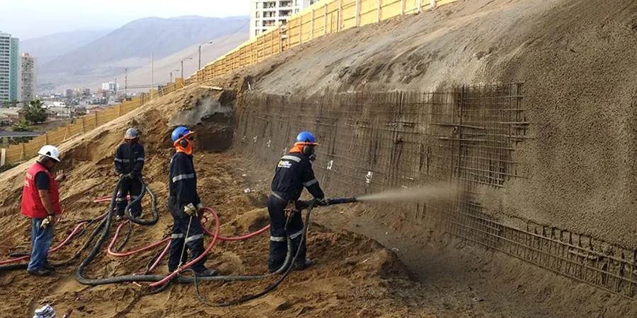
Every slope analysis in Balbriggan starts with a tailored ground investigation. Depending on the site access and the failure mechanism suspected, we deploy different field techniques to build the geological model before a single calculation runs.
Field Investigation and Instrumentation
Cable percussion boreholes and dynamic probing to map the till-bedrock interface, plus standpipe piezometers and inclinometer casings for monitoring pore pressures and lateral displacements over a full seasonal cycle.
Laboratory Strength Testing
Multi-stage triaxial (CIU and CID) and direct shear tests on undisturbed samples taken from the critical slip zone, providing the peak and residual strength envelopes needed for both first-time and reactivated slides.
Stabilization Design and Specification
Regrading plans, trench drains, soil nailing, and anchored mesh systems designed to achieve the target factor of safety, with construction-phase supervision and contingency triggers defined in advance.
Frequently asked questions
How much does a slope stability analysis cost for a site in Balbriggan?
The fee typically ranges between €1,240 and €3,880, depending on whether the slope is a small garden embankment or a large roadside cutting. The price covers the site visit, the limit-equilibrium modeling, and the interpretive report with stabilization recommendations. If a dedicated ground investigation with boreholes and lab testing is needed, those costs are quoted separately based on the number of exploratory points and the testing schedule.
What triggers a slope failure in glacial till around Balbriggan?
In our experience, the most common trigger is prolonged rainfall combined with a blocked or broken drainage system. The boulder clay here has a high silt content, so it holds water and loses suction slowly over several days of wet weather. Construction activity at the toe—even a small excavation for a utility trench—can also remove passive support and initiate a progressive failure that may not be visible for months.
Do I need a slope stability report for a planning application in Fingal?
Fingal County Council will request a slope stability report whenever the proposed development lies within a zone of high slope risk or involves cuts and fills greater than 1.5 meters in height. The report must demonstrate compliance with Eurocode 7 and include factors of safety for both temporary and permanent conditions. We coordinate directly with the council’s geotechnical reviewer to ensure the scope of the investigation matches the planning conditions.