In Balbriggan, the ground beneath a site can shift from stiff Dublin till to loose estuarine sands within fifty meters, especially near the harbour or along the Bracken River floodplain. The real headache comes when buried channels cut through the till—pockets of soft, saturated sediment that standard boreholes miss completely. Electrical resistivity surveys let us map those contrasts without digging half a dozen test pits first. By running a VES vertical electrical sounding across a grid, we build a continuous profile of the subsurface, flagging low-resistivity zones that usually mean wet clay or saline groundwater intrusion. For a town that's seen a surge in residential extensions and small industrial units along the M1 corridor, getting the ground model right before breaking ground saves both time and foundation over-engineering.
Resistivity in Balbriggan isn't just about finding bedrock—it's about mapping saline wedges that corrode concrete piles within a decade.
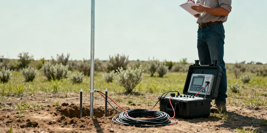
Methodology applied in Balbriggan
Risks and considerations in Balbriggan
We've seen a few Balbriggan builds—particularly two-storey extensions near the railway line—where the engineer assumed uniform boulder clay across the site, only to hit a lens of saturated silty sand at three metres during excavation. The pit flooded, the neighbouring wall started to crack, and the contractor spent three weeks on emergency dewatering and underpinning. That's the classic buried channel problem. Resistivity profiling would have caught that lens before the digger arrived. The data shows up as a sharp drop in apparent resistivity on the pseudosection, and once you correlate it with a single borehole log, the whole subsurface model tightens up. When you're building within a hundred metres of the Irish Sea, ignoring saline groundwater paths isn't just a technical oversight—it's a durability risk for any reinforced concrete in the ground.
Our services
Our electrical resistivity work in Balbriggan is built around two practical survey formats—one for quick site screening and one for deeper subsurface imaging. Both include data processing, inversion modelling, and a report that ties resistivity sections to the known geology of the Fingal area.
2D Resistivity Profiling for Site Screening
A single or multi-line survey with electrode spacing between 2 and 5 metres, ideal for spotting shallow buried services, backfilled areas, or perched groundwater pockets. We use this a lot on brownfield sites along the Balbriggan quays where old infill is common.
Deep VES Sounding for Bedrock and Groundwater Mapping
A vertical electrical sounding program with AB/2 expansion up to 100 metres, targeting bedrock depth and saline intrusion boundaries. Suitable for foundation design, quarry assessment, and water supply borehole siting in the Balbriggan hinterland.
Frequently asked questions
How much does an electrical resistivity survey cost for a typical residential site in Balbriggan?
For a standard residential plot with one or two VES soundings and a short 2D profile, the work usually falls between €600 and €860. The final figure depends on access conditions, electrode spread length, and whether we need to combine it with a single borehole for calibration.
Can resistivity tell the difference between fresh and saline groundwater near the coast?
Yes, and that's one of the main reasons we run these surveys in coastal towns like Balbriggan. Saltwater-saturated sand has a resistivity below 10 ohm-m, while freshwater-bearing gravel or till sits much higher, typically above 30 ohm-m. The contrast on the inverted section is sharp and easy to map.
How deep can you investigate with resistivity around Balbriggan?
With a Schlumberger array and AB/2 distances up to 100 metres, we routinely reach 40 to 50 metres in the local boulder clay. In higher-resistivity bedrock, the effective depth can increase. Shallower surveys for foundation-level mapping target the top 10 to 15 metres.
Do I need a resistivity survey if I already have borehole logs?
Boreholes give you point data. Resistivity ties those points together into a continuous section. In Balbriggan, where buried channels and lateral changes in the till are common, boreholes alone can miss the soft pockets. Combining both methods gives you the most reliable ground model.